Skip to main navigation Skip to main content

Karst Geology and Hydrogeology

What is Karst?

​​​​​​​​​​​​​​​​​​​​​​​​​​​​​​​​Karst is a terrane formed from the dissolution of soluble rocks such as limestone, dolomite, and gypsum. It is characterized by underground drainage systems with sinkholes and caves. Kentucky is one of the most famous karst areas of the world. Much of Kentucky's prime farmland is underlain by karst. A substantial portion of the Daniel Boone National Forest, with its important recreational and timber resources, is underlain by karst. Caves also provide recreational opportunities and contain unique ecosystems. Mammoth Cave, with over 350 miles of passages, is the longest surveyed cave in the world. Springs and wells in karst areas supply water to thousands of homes.

Illustration of karst terrane 

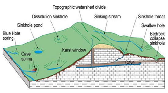
Karst terranes are often characterized by the rapid movement of water through underground channels and conduits. This rapid movement of water renders karst terranes sensitive to groundwater pollution. Because of the importance of karst to Kentucky, we are vitally interested in the study, evaluation and protection of karst terranes. Karst investigations focus on mapping the extent of karst basins through dye tracing, the characterization of groundwater quality, and the evaluation of karst hazards.


Groundwater Data

Groundwater data collected across Kentucky are available through several viewers and databases. These resources provide access to ambient monitoring results, well records, and karst investigations allowing users to explore groundwater quality, location, and hydrogeologic conditions statewide. Whether you are a researcher, regulator, consultant, or member of the public, the viewers and portals below offer multiple ways to search, visualize, and download groundwater information to meet your needs.​

Ambient Groundwater Monitoring Network (GWMN) Viewer

  • The Kentucky Division of Water has systematically sampled ambient groundwater for more than 20 years through its statewide monitoring network.
  • Explore sampling locations and analytical results from the GWMN using an interactive map.

Kentucky Groundwater Data Repository

Kentucky Karst Dye Trace Database

  • Dye trace studies and maps provide groundwater flow information in karst terrane areas. Find downloadable dye trace maps and study data on the UKnowledge portal.

KYGovMaps Open Data Portal

  • Search the Open Data Portal using keywords "DOW," "groundwater," or "karst" for various downloadable GIS datasets and map services related to groundwater resources.

Well Record Information Map

  • This interactive map is maintained to provide well drillers with the location information they need to submit a well record to the Kentucky Division of Water. After clicking on a location of interest a pop-up window provides the quadrangle, county, region and elevation. The map is also useful for viewing the number of wells present within a site of interest.


Kentucky Energy and Environment Cabinet
300 Sower Blvd
Frankfort, KY 40601    

Phone Directory
Contact Us
Civil Rights/Derecho Civiles

The Kentucky Energy and Environment Cabinet does not discriminate against any person on the basis of race, color, national origin, religion, age, disability or sex. This policy protects the rights of Cabinet employees, service applicants and customers. Vendors, agencies and organizations providing services to the Cabinet or its recipients of federally-aided programs also must comply with this policy.